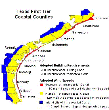
Chambers
County
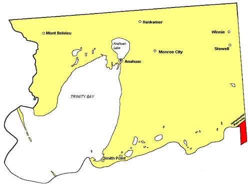

Chambers
County
List
of Communities
The following is a list of communities located in Chambers County.
The communities have been catagorized according to the zone they
fall under. If a structure is located in a community or area not
shown below, then refer to the county map to determine which zone
the structure falls under.
INLAND
I - 2000 IBC/IRC with the Texas Revisions, 120 mph 3-second
gust design wind speed
Anahuac,
Beach City, Cove, Double Bayou, Eminence, Figridge, Four Corners,
Hankamer, Monroe City, Mont Belvieu, Oak Island, Sea Breeze, Smith
Point, Stowell, Turtle Bayou, Wallisville, Winfree, Winnie.
Written Description of Dividing Line Between Inland I and Inland
II Zones: Chambers County: Continuing from the intersection
of the Galveston/Chambers/Harris County lines north along the
Harris/Chambers County line to the intersection of the Harris/Chambers/Liberty
County Line; continuing east along the Chambers/Liberty County
line to the intersection of the Jefferson County line and continuing
east and south along the Chambers/Jefferson County line to the
intersection of Interstate Highway 10.
Harris
County
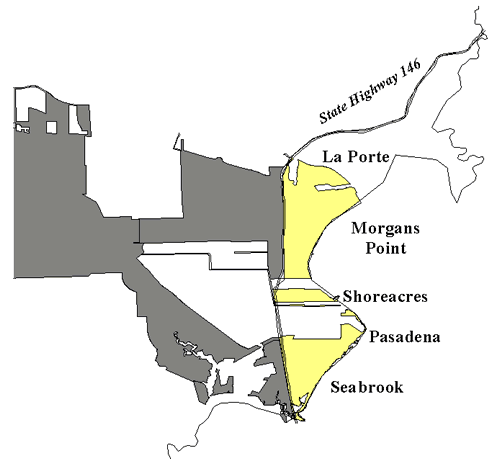

Harris
County
List
of Communities
The following is a list of the communities located in Harris County
that are part of the designated catastrophe area. The communities
have been catagorized according to the zone they fall under. If
a structure is located in a community or area not shown below,
then refer to the county map to determine which zone the structure
falls under.
INLAND I - 2000 IBC/IRC with the Texas Revisions, 120 mph
3-second gust design wind speed
La Porte, Morgans Point, Pasadena, Seabrook, Shoreacres.
Written description of the areas designated as Inland I:
Areas located east of State Highway 146 and inside the city limits
of the cities of Seabrook, La Porte, Shoreacres, Pasadena, and
Morgan’s Point (all in Harris County).
Galveston
County
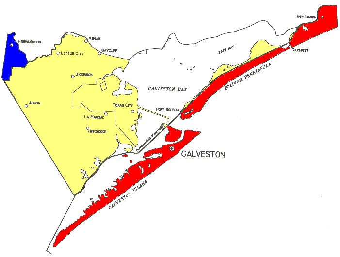

Galveston
County
Notes:
All structures located inside the city limits of a city or town
which is divided by the dividing line between inland I and inland
II shall be subject to the Inland II requirements.
List
of Communities
The following is a list of communities located in Galveston County.
The communities have been categorized according to the zone they
fall under. If a structure is located in a community or area not
shown below, then refer to the county map to determine which zone
the structure falls under.
INLAND
II - 2000 IBC/IRC with the Texas Revisions, 110 mph 3-second
gust design wind speed
Friendswood
INLAND I - 2000 IBC/IRC with the Texas Revisions, 120 mph
3-second gust design wind speed
Algoa, LaMarque, Bacliff, League City, Bayview, Nadeau, Bayou
Vista, San Leon, Clear Lake Shores, Santa Fe, Dickinson, Texas
City, Galveston, Texas City, Junction, Hitchcock, Village of Tiki
Island, Kemah, Virginia Point
SEAWARD
- 2000 IBC/IRC with the Texas Revisions, 130 mph 3-second
gust design wind speed
Caplen, Crystal Beach, Flake, Galveston, Galveston Island State
Park, Gilchrist, High Island, Hitchcock, Jamaica Beach, Port Bolivar.
Written Description of Dividing Line Between Inland I and Inland
II Zones: Galveston County: Beginning at the Brazoria/Galveston
County line intersection with State Highway 6 and continuing northward
along the Galveston County line to the southern city limits of
the City of Friendswood, Texas; continuing to follow the eastern
city limits of the City of Friendswood, Texas, north to the Galveston/Harris
County line; continuing to follow the Galveston County line east
to the intersection of the Galveston/Chambers/Harris County lines.
Brazoria
County


Brazoria
County
Notes:
(a) Except as specified in (b) below, all structures located inside
the city limits of a city or town which is divided by the dividing
line between inland I and inland II, shall be subject to the Inland
II requirements. (b) Structures located in Angleton shall be subject
to the Inland I requirements regardless of whether the city is
separated by the dividing line between inland I and inland II.
List
of Communities
The following is a list of communities located in Brazoria County.
The communities have been categorized according to the zone they
fall under. If a structure is located in a community or area not
shown below, then refer to the county map to determine which zone
the structure falls under.
INLAND II - 2000 IBC/IRC with the Texas Revisions, 110
mph 3-second gust design wind speed
Alvin, Iowa Colony, Anchor, Lochridge, Bailey’s Prairie, Manvel,
Bonney, Old Ocean, Brookside Village, Otey, Chenango, Pearland,
Damon, Rosharon, Danciger, Sandy Point ,Hastings, The Heights,
Holiday Lakes, West Columbia
INLAND I - 2000 IBC/IRC with the Texas Revisions, 120 mph
3-second gust design wind speed
Amsterdam, Hoskins, Angleton, Jones Creek, Brazoria, Lake Jackson,
Chocolate Bayou, Liverpool, Churchill Bridge, Mims, Clute, Oyster
Creek, Danbury, Richwood, East Columbia, Rivers End, Freeport,
Snipe, Four Corners, Stratton Ridge, Gulf Park, Sweeny, Hillcrest
Village, Van Pelt, Hinkles Ferr,y Velasco
SEAWARD - 2000 IBC/IRC with the Texas Revisions, 130 mph
3-second gust design wind speed)
Quintana, Surfside Beach
Written Description of Dividing Line Between Inland I and Inland
II Zones: Matagorda and Brazoria Counties: Beginning at the
Jackson/Matagorda County line intersection with F.M. Road 616
and continuing northeasterly to the intersection of F.M. Road
616 with State Highway 35; continuing northeasterly along State
Highway 35 through Matagorda and Brazoria County to the intersection
of State Highway 35 with F.M. Road 521; continuing north along
F.M. Road 521 to the intersection of F.M. Road 521 with F.M. Road
523; continuing northeasterly along F.M. Road 523 to the intersection
with the northwest city limits of the City of Angleton, Texas,
and following the western city limits of the City of Angleton
to the intersection of the city limits of the City of Angleton
with F.M. Road 523; continuing along F.M. 523 to the intersection
of F.M. Road 523 with State Highway 35; continuing along State
Highway 35 to the intersection of State Highway 35 with State
Highway 6, continuing east on State Highway 6 to the Brazoria/Galveston
County line.